
Ireland

![]()
![]()
Travels on foot and by campervan to Kerry, Dingle, the Burren, Connemara, Donegal and much more. Island of bog and mountain, endless vistas, cool winds and warm hearted people. Land of Cuchullain, Fionn and the Salmon of Knowledge, Tír nan Óg and much much more.
Suzy and I first visited Ireland in August 1994 and she still reminds me that it rained every day, though not all the time you understand. On that first visit to this land of legend we dropped in at some of the tourist traps and amongst international crowds she kissed the blarney stone even though I tactfully tried to suggest that it probably wasn't necessary. We also climbed Brandon mountain in serious rain with the cloud down to the valley and went to Conemara to climb the 12 Pins and got wet there too. There were many good things on that holiday however, one was the Guinness a second was that I spotted some of the climbing potential on the sea cliffs of Kerry.
In those days we would travel in an old estate car which we used as living and sleeping acommodation, now we own a campervan and things are a lot more civilized.
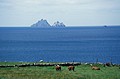
You can't take your campervan to the Skellig islands and even if you did, there'd be nowhere to drive it, they lie as rocky excrescence some 14 km off the coast of Kerry. Suzy and I sailed from the beautiful small town of Portmagee, a trip that takes just over an hour. The boat first passes Little Skellig where there are literally thousands of nesting sea birds, mostly Gannets, it's possible to make out the white bird droppings covering the right hand island. The boat arrives at a small slipway tucked in below a large cliff that was built for the construction of the lighthouse in the 19th century. From a little way along a walkway 670 steps have been cut into the rock by the monks of St Finan in the 9th century, these lead to the stone beehive huts - cells for the monks. The 6 huts have a circular exterior but a rectangular interior and look anything but cosy. There were also some amazing small gardens where they grew vegetables and systems for collecting rain water. Picture 2 shows two of the bee hive huts plus a visitor. Little Skellig can be seen in the middle distance and the mainland behind.
The highest point of the island is 217m that can only be reached by an airy and slightly dangerous scramble. On the top is a rusted cross. The monks were almost certainly supported by pilgrims from the mainland though in periods of bad weather the island would have been unapproachable as there were no easy landings before the lighthouse was built. The monastery was abandoned in the 13th century, possible due to deteriorating climatic conditions but also due to a trend towards larger religious establishments on the mainland.

Next time we visited was June 2000 and it rained quite a lot, despite my maintaining that the place wouldn't be 40 shades of green without a bit of rain. During that holiday we climbed Brendan and it must have been something of an oversight on His part because the sun came out and there were stunning views. Picture 3 shows some of the Brendan range on the Dingle Peninsular from a small cove on the North side near Cilcummin. Brandon Mountain in to the right off-picture , the hill in the background is probably Stradbally Mountain (824m). The pink flowers in the foreground are Ragged Robins (Lychnis flos-cuculi), behind is Fermoyle House. We moved on heading North into Conemara and Donegal where we had a LOT of rain.
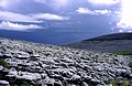
After that, Suzy said that she wasn't going to Ireland ever again because it always rained. I said that when I go climbing there in May of June the sun always shines (with one exception). So against her better judgment we loaded the campervan and returned. We visited the Burren in Co. Clare back in 2000 part way through our holiday, this time we headed there at the start of our holiday, just as a long line of Atlantic weather fronts lined themselves up with the West coast of Ireland and Scotland in order to treat us to some of the wettest and windiest May weather for many a year. Four, the uplands of the Burren hills contain some of the best examples of limestone pavements in the British Isles. Many rare plants are concealed within them and on the hillsides below.
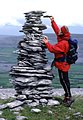
Left, that's Suzy, vertically challenged whiles adding to a cairn on the SE end of a ridge with the odd name of Cappanawalla. The Burren has many curious cairns, not all as tall as this one. A popular pastime seems to be upending large flakes of weathered limestone into holes in the pavements to give a sort of graveyard impression.
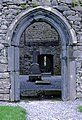
Next is a Burren limestone pavement for which it is justifiably famous and right is a picture taken inside Corcomroe Abbey. This Cistercian abbey was founded by the O'Brians and was originally called Sancta Maria de Petra Fertili - Saint Mary of the fertile rock. The abbey is built from the local limestone with what appears to be sandstone for the carvings. It's well looked after and there are explanatory displays. Click on image for a view of the abbey tucked up against the grey limestone of Abbey Hill. It was typical of the Cistercian monks to site the abbey in a remote place. Inside, most of the abbey's layout remains intact and many of the intricate carvings and archway detail seems to have avoided the vandalism of centuries that is so often seen in more accessible ruins.
We chose to approach it by a small path that leads up from the road, as shown on the Burren Ramblers Guide and Map, available from the Whitethorn visitors centre. It didn't seem to have been used since the occupation of the abbey. It was all water and prickly bushes. We later discovered that it doesn't appear on any other map. Now we know why.


Left shows just a few of the impressive and inaccessible cliffs north of the boglands of Co, Mayo. A new adventure playground for us climbers?
For poetry lovers, Co. Sligo is famous for W.B.Yeats, Ireland's most famous bard. A fairly innocuous mountain called Benbulben (Binn Ghulbain) is however famous for rare plants. The south side has pleasant limestone escarpments, the top is peat and the raries live in awkward places on small limestone outcrops on the North edge. We, or rather Suzy found the Irish Sandwort Arenaria ciliata (or was it norvegica?). A rather unassuming little number. However, continuing our walk eastwards along the ridge the views South across innumerable bright green wet fields were splendid. Escape from the ridge to the South can be problematical due to the long limestone escarpments. However, there is a convenient and ancient mule track at Largandoon, leading down to the East end of Glencar Lough (Loch Ghleann an Chairthe). Picture 2.
Another excellent walk from the Lonely Planet guide was The Poisoned Glen (picture 3) and the traverse of Slieve Snaght. There were however a couple of mistakes in the description and the references to south-eastwards on pages 350 and 351 should read south-westwards. The descent down by the Devlin river was VERY wet. It did look possible however to traverse below the North side of the ridge on drier ground before losing height to the starting point.
According to our Lonely Planet walking guide the glen may have got its name from the Euphorbias that once grew there. However, Donna Kelly has kindly written to offer a more likely explanation as follows.
Donegal's Poisoned Glen was originally known in Irish as Gleann Neamh - Heaven's Glen. During the plantation of Ireland by English and Scottish settlers, the English decided to catalogue the Irish place names. They did this phonetically, recording the names with anglicised spelling. Hence, Gleann Neamh was written in a phonetic fashion something like 'Glen Nev'. On translation back into Irish (possibly last 1800s early 1900s), when there was something of a drive on to reclaim place names, the name of the Glen was read phonetically from an Irish point of view - hence 'Glen Nev' became Gleann Nimhe - which translates back into English as "The Poisoned Glen".
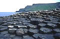
The North Antrim coast is one of the jewels of all Ireland, featuring the daunting cliffs of Fair Head, a superb cliff path and of course The Giant's Causeway, a World Heritage Site. Despite its popularity it is an essential visit and a hauntingly beautiful place. These 40000 hexagonal columns are reputed to be formed by the cooling of liquid basalt some 60 million years ago; a likely story! It was almost certainly built by the Irish Giant Finn MacCool (Fionn Mac Cumhaill) as a causeway to reach his beloved in Scotland. Proof of this are the identical basalt columns found on the Isle of Staffa.
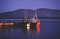
Last light at Reenard Point Co. Kerry. Included because I just like it. I was surprised that the photograph came out, we'd just emerged from The Point Bar after the legendary Monkfish followed by several pints of the black stuff.
chris.jackson@zen.co.uk
Travels on foot and by campervan to Kerry, Dingle, the Burren, Connemara, Donegal and much more. Island of bog and mountain, endless vistas, cool winds and warm hearted people. Land of Cuchullain, Fionn and the Salmon of Knowledge, Tír nan Óg and much much more.